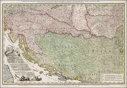
SCHÜTZ, CARL: MAP OF BOSNIA, SERBIA, CROATIA AND SLAVONIA WITH NEIGHBOURING COUNTRIES
The map shows the territory of the then Bosnia, Serbia, Croatia and Slavonia and parts of neighbouring countries. The Turkish territory is indicated in green, the Austrian in pink and that Venetian in yellow. On the territory of present day Croatia, the boundaries are marked of Slavonia, Croatia, the Republic of Dubrovnik and a part of the Venetian Republic, which comprised much of Istria and Dalmatia. In Istria, the boundaries delineating the Principality of Pazin (central part of Istria) that belonged at the time to the Habsburg Monarchy are indicated, as well as those identifying the part of Istria that at that time formed part of the Venetian Republic. The inland zone of the Republic of Dubrovnik and the Popovo polje valley are incorrectly identified as making part of the Venetian Dalmatia. The map shows roads, which was relatively rare for the period. The title of the map is in the lower right corner in a sumptuous cartouche also comprising military symbols glorifying victories over the Turks. This map was compiled during the last Turkish-Austrian war ended in 1791 and after which the Turks were definitely driven out of Croatian lands to the territory of Bosnia. In the lower right corner of the map the signatures of engravers are placed reading: C. Schütz i F. Müller. The map scale is expressed in German, French and Hungarian miles.
SCHÜTZ, CARL
