SANTINI, PIETRO: SLAVONIA, SYRMIA
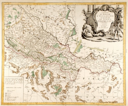
A very detailed general map of Slavonia, which includes a part of Bosnia to Sarajevo, with a specially marked border of the newly freed area along the Sava River. Slavonia occupies the area between Sava, Drava and Danube to Ilok, continues to Vojvodina and Belgrade, all between the Danube and Sava rivers. In the west, Slavonia stretches to Moslavačka gorja and Kutina as the westernmost town. The map contains many toponyms, a river network, forests and marshes, and some reliefs depicted with shadowy molehills. A lavish Baroque cartouche with man and women figures is in the upper right corner. From the legend in the lower left corner, we find that the map was partially conceived according to the designs of Josip Gadea and that the borders are laid down according to the Peace Agreements signed in Požarevac and Belgrade.
SANTINI, PIETRO
