RIEDEL, ADRIAN FRANZ XAVER FLORIAN VON: MAP OF THE AUSTRO HUNGARIAN MONARCHY
Inventory number 387
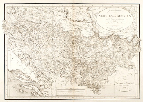
Original title: Generalkarte von Servien and Bosnien nach der Charte in vier Blattern von Riedl
Publishing year: 1812
Place of publishing and publisher: Wien / Berlin
Format: 42 x 60 cm
Technique: Steel engraving
The map is, as indicated in the title, a very diminished representation of the famous J. Riedl map of 1810 (see 231 in Collectio). The map was created based on Austrian military maps and contains abundant previously unknown information, including numerous small village toponyms and routes. Unfortunately, a significant reduction of Riedl's map significantly reduces its legibility.
RIEDL, ADRIAN FRANZ XAVER FLORIAN VON
RIEDL, ADRIAN FRANZ XAVER FLORIAN VON (1746-1809), a topographer and cartographer from Munich. His most significant works are Stromatlas von Baiern, created between 1806 and 1808, Reise Atlas von Bajern oder Geographisch-geometrische Darstellung aller bajrischen Haupt- und Landstrassen mit den daranliegenden Ortschaften und Gegenden: nebst Kurzen Beschreibungen alles dessen, was auf und an einer jeden der gezeichneten Strassen für den Reisenden merkwürdig seyn kann, published in five volumes (1796–1805), Moldau from 1811 and Servien und Bosnien, which was published as a map consisting of four sheets in 1810, and then republished in 1812. His father, CASTULUS RIEDL (1701-1783), from Freising, was a cartographer and mathematician in the Court Exchequer. He lived in Munich.
