SANSON, NICOLAS: CROATIA, BOSNIA AND HUNGARY
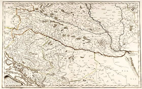
The map shows the area of the southern part of Hungary stretching all the way to the Sava River and includes the entire Zagorje, Slavonia and Zagreb. Zagreb (Zagrabia) was mistakenly located near Sisak, but Agram was also labeled at approximately the right place, east of Mokrice (this is an error that is repeated from Mercator's maps). Croatia covers the area south of Sava, up to the sea, but only from Žrnovica to Obrovac, while the islands and coastline from Nin to Šibenik are a part of Venetian Dalmatia. Bosnia is squeezed between Sava to the north and Drina in the west, while the eastern boundary begins at Jasenovac and extends south to the well of Krka River. Bosnia is separated from the sea in the south by the entire Herzegovina, i.e. Venetian Dalmatia, which points to the influence of Venetian cartography. Relief is still indicated in the form of mollehils, but forests, most of which are in Slavonia and along the northern coast of the Drava River, are marked in a particularly interesting way.
SANSON, NICOLAS
