THOMSON, JOHN: NORTHERN OTTOMAN EMPIRE IN EUROPE
Inventory number 416
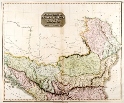
Original title: North Part of Turkey in Europe Comprehending Ancient Illyricum and Dacia, Moesia,…
Publishing year: 1817
Place of publishing and publisher: Edinburgh
Format: 49,5 x 59 cm
Technique: Partially coloured lithograph
The map shows the entire area from the Black Sea to the Adriatic Sea, but the political boundaries marked with various shades of pink and green are rather confusing. At the time of making the map, Serbia had already acquired partial autonomy (1815), while on the map it is a part of the Ottoman Empire. Herzegovina occupies the entire territory of southern Bosnia, from Neretva to Una rivers, while Bosnia is divided by the Radissa and Ivan mountain chain which is difficult to identify. It also confuses the name Illyricum, which denotes Dalmatia, Herzegovina and Albania, and which makes a rather illegible map even more illegible. The map is printed in Thomson's New General Atlas and uses the new lithography technique, which was first used in 1812 by James Wyld (1790-1836), map maker, printer and cartographer.
THOMPSON, JOHN
THOMSON, JOHN (1777-1840), a Scottish cartographer, engraver and publisher, particularly known for his atlases, which he made in Edinburgh. Together with J. Cary and J. Pinkerton, he is considered one of the most significant British cartographers of the time. He redefined European cartography with a critical approach and by rejecting excessive decoration. One of his most well-known published works is A New General Atlas of the World, for which a new lithography technique was used from 1814. A part of the maps, including the maps of the European part of Turkey, for this atlas was drawn by James Wyld (1790-1836), map plotter, printer and cartographer. In addition to him, N.R. Hewitt also worked on the atlas.