REILLY, FRANZ JOHANN JOSEPH VON: MAP OF THE DUCHY OF STYRIA, CARINTHIA AND CARNIOLA
Inventory number 112
Author: REILLY, FRANZ JOHANN JOSEPH VON
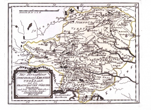
Original title: Die Herzogthümer Steymark, Kaernten und Krain mit den Grafschaften Görz und Gradisga und dem Triester gebiethe in der ämtlicher Sprache Innerostreich: Nro 130
Publishing year: 1789
Place of publishing and publisher: Wien
Format: 22 x 28 cm
Technique: Copper engraving
The map of Styria, Carinthia and Carniola with the counties of Gorica and Gradiška and the district of Trieste, shows their mutual boundaries and the administrative territorial organization. The topography is shown in a very arbitrary way, with shaded molehills. Forested areas of the lower Carniola are accentuated by inscription of a group of trees. By the mark of a star-like circle are represented major towns, while smaller places are marked by a symbol of church. The title of the map is in the lower left corner of the map in a panel illustrated with a simple branch decoration. A mileage scale is in German miles (Deutche M.). This map is published in Relly's atlas "Schauplatz der Welt Atlas" 1789-1791.
REILLY, FRANZ JOHANN JOSEPH VON
FRANZ JOHANN JESEPH VON REILLY (1766-182), a Viennese cartographer, publisher and merchant. His most famous work is "Schauplatz der Welt Atlas" 1789-1791, that includes a number of maps of the Croatian lands. It was printed in Vienna in the printing house of Ignaz Albrecht. Other Railly's works of importance are "Deutscher Atlas" of 1796 and "Atlas Univ." of 1799.
