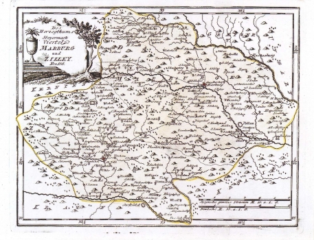
REILLY, FRANZ JOHANN JOSEPH VON: KARTE VOM HERZOGTUM STEIERMARK, BEZIRK MARBURG (MARIBOR) UND ZILLEY (CELJE)
The map shows the districts of the towns of Maribor and Celje within the duchy of Styria. The delimitation between the two districts is indicated with dotted line. The star-like circles (schematized representation of a fortress) indicate major settlements, and smallest ones by a symbol of a church (a circle with a cross). The network of rivers is shown with great detail, as well as all major settlements. The post route Maribor-Celje with all its stations is presented very attentively. Just like on all the other Reilly's maps, the topography is shown in a very inadequate way. Forests are represented by a tree-symbol. The title of the map is in the upper left corner inscribed in a stone monument. A mileage scale is in German miles (Deutsche M.) and in common Styrian miles (Steyrische gemeine Strassen M.). This map is published in Reilly's atlas "Schauplatz der Welt Atlas" 1789-1791.
REILLY, FRANZ JOHANN JOSEPH VON
