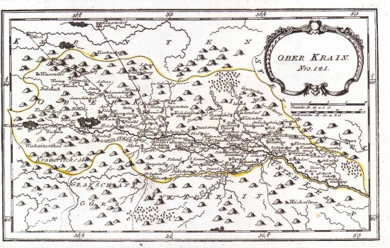
REILLY, FRANZ JOHANN JOSEPH VON: MAP OF UPPER CARNIOLA
Inventory number 127
Author: REILLY, FRANZ JOHANN JOSEPH VON
Original title: Ober Krain: Nro 141
Publishing year: 1789
Place of publishing and publisher: Wien
Format: 18,5 x 30 cm
Technique: Copper engraving
The Upper Carniola is a part of the duchy of Carniola situated to the north of the river Sava. The map shows major settlements. The post route Ljubljana-Kranj and its branching-off towards Klagenfurt and Villach are indicated with fine engraving. The forested character of the area nearing the border with Styria is presented with tree-symbols. The title of the map is in the upper right corner of the map in an oval cartouche. A mileage scale is in German (Deutshe M.) and Italian (Italienische M.). This map was published in Reilly's atlas "Schauplatz der Welt Atlas" 1789-1791.
REILLY, FRANZ JOHANN JOSEPH VON
FRANZ JOHANN JESEPH VON REILLY (1766-182), a Viennese cartographer, publisher and merchant. His most famous work is "Schauplatz der Welt Atlas" 1789-1791, that includes a number of maps of the Croatian lands. It was printed in Vienna in the printing house of Ignaz Albrecht. Other Railly's works of importance are "Deutscher Atlas" of 1796 and "Atlas Univ." of 1799.
