REILLY, FRANZ JOHANN JOSEPH VON: MAP OF THE COUNTIES OF GRADIPKA AND GORICA WITH TOLMIN
Inventory number 128
Author: REILLY, FRANZ JOHANN JOSEPH VON
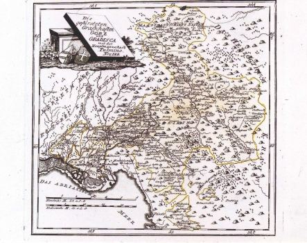
Original title: Die gefürsteten Grafschaften Görz und Gradisca mit der Hauptmannschaft Tulmino: Nro 144
Publishing year: 1789
Place of publishing and publisher: Wien
Format: 26,5 x 27 cm
Technique: Copper engraving
The map shows the counties of Gorica and Gradiška and the captaincy of Tolmin. By a dotted line are shown the boundaries between the counties and the captaincy. A yellow line shows their external borders. The topography is poorly represented without a clear layout. A tree-symbol is largely used to stress the forested character of the greatest part of the regions shown. Gorica is represented as large postal center situated at the crossroads of routes leading in Vipava, Trieste and Udine directions. The title of the map is in upper left corner inscribed in a stone monument. A mileage scale is in German (Deutsche M.) and Italian (Italienische M.). This map was published in Reilly's atlas "Schauplatz der Welt Atlas" 1789-1791
REILLY, FRANZ JOHANN JOSEPH VON
FRANZ JOHANN JESEPH VON REILLY (1766-182), a Viennese cartographer, publisher and merchant. His most famous work is "Schauplatz der Welt Atlas" 1789-1791, that includes a number of maps of the Croatian lands. It was printed in Vienna in the printing house of Ignaz Albrecht. Other Railly's works of importance are "Deutscher Atlas" of 1796 and "Atlas Univ." of 1799.
