SCHEDA, JOSEPH: MAP OF THE AUSTRIAN HUNGARIAN EMPIRE - SECTION XVIII
Inventory number 420
Author: SCHEDA, JOSEPH
Original title: General-Karte des Oesterreichischen Kaiserstaates mit einem grossen Theile der angrenzenden Länder
Publishing year: 1856
Place of publishing and publisher: Wien
Format: 49,5 x 56,5
Technique: Copper engraving
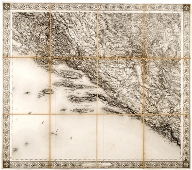
The map shows the coast from Zadar to Budva with hinterland and represents the 18th section of the large map of the Austro-Hungarian Monarchy, which consists of 20 sections at the scale of 1:576 000. Croatian regions are shown on sheets 12, 13, 14, 17 and 18. According to M. Marković in "Descriptio Croatiae", "The map is technically flawlessly crafted, but it is overwhelming and therefore its legibility is reduced."
SCHEDA, JOSEPH
SCHEDA, JOSEPH (1815-1888), a military geographer and cartographer, who worked at the Institute of Military Geography in Vienna. He reformed and advanced the topographic map legend. In 1856, the Institute published a general map of the Austro-Hungarian Monarchy in 20 sections. His most significant works are Karte des österr.-ungar Reiches, Generalkarte von Zentraleuropa in 47 sheets, Karte von Europa in 27 sheets from 1845 to 1947, Generalkarte des Österreichisches Kaiserstaates mit einem grossen Theile der angrenzender Ländern from 1856 and the Handatlas in 14 Blatt zur mathematischen und physikalischen geographie from 1874.
