SCHEDA, JOSEPH: CROATIA AND SLAVONIA
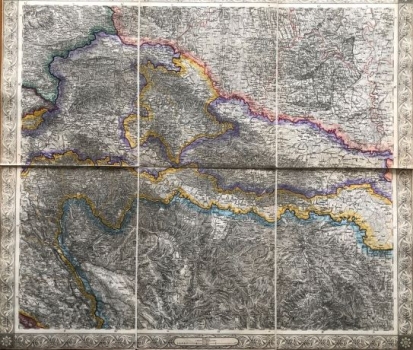
This richly hatched and partially coloured topographic map of Austrian imperial possessions in Croatia and Slavonia also shows some neighboring countries. It shows the area from Maribor (Marburg) in the northwest to Vukovar in the east and Starigrad and Gračac in the south. This was the time of stabilization of the Austrian-Ottoman border, before the demobilization of 1873 and the abolition of the Military Frontier system in Slavonia and Croatia and the union with the home country in 1881. Slavonia is divided, which is emphasized by colour, into military and civilian parts. Slavonian counties Požega, Virovitica and Srijem were directly represented in the Hungarian Parliament from 1745. Military part consists of Brod, Gradiška and Petrovaradin Regiments. Varaždin Frontier consists of the Križevci and Đurđevac Regiments and one can also see the Ban Frontier with the First and Second Ban Regiments. Despite emphasizing the political boundaries with Bosnia (according to the provisions of the Treaty of Sistova 1791), emphasis was also placed on the physical-geographical elements of the displayed territory. First, it refers to high quality elements of a very dynamic relief, which is plasticized by hatching. The map is based on the Francis I topographic survey carried out between 1806 and 1869. The map is a part of the general map of the Austrian Empire, which was issued in 20 sheets by Scheda, Chief of the Military Geographic Institute in Vienna in 1856. Therefore, the origin and reasons of its high quality are clear. The richly decorated frame includes a numerical and graphical scale. The scale is 1: 576 000. The sheet label (XIII) is located on top of the decorative map frame.
SCHEDA, JOSEPH
