ROUX, JOSEPH: POREČ
Inventory number 500
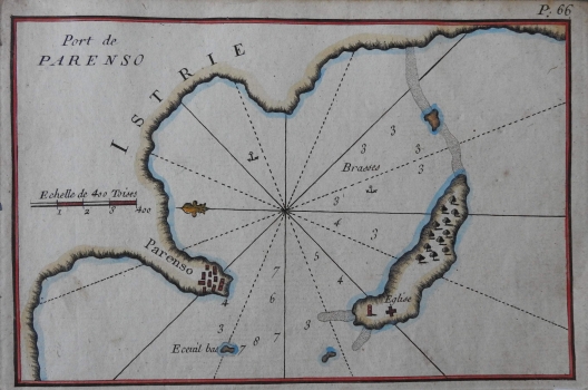
Original title: Port de Parenso
Publishing year: 1764
Place of publishing and publisher: Marseille
Format: 12 x 19 cm
Technique: Partially coloured copper engraving
The chart shows the port of Poreč with bathymetric data, islands and shallows in front of the peninsula. Vegetation on the island of St. Nicholas is particularly emphasized. The plan is a part of the Roux edition of the Recueil des Principaux Plans, des Ports, et Rades de la Mer Mediterranée, estraits de ma carte en Douze Feuilles dediee a M.le Duc de Choiseul from 1764. This is the year of the first and only edition of a rare collection of 170 charts, featuring representations of ports from all over the Mediterranean. Roux investigated and mapped the less known Adriatic and eastern Mediterranean ports for French cartography as their own contribution to a more successful navigation towards Levant. Particularly well represented are charts of eastern Mediterranean ports, which had been rare before the middle of the 18th century. As a French royal hydrographer (Hidrographe du Roy), Roux paid special attention to navigational data such as precise location of islands and islets, landline markers or information on underwater depths. On this plan, these data are expressed in fathoms (Brasses). Plans are numbered, so this one carries the P 66 mark above the upper edge of the chart. Each sheet has a separate title and a graphical scale, expressed in different measuring units. The compass rose is divided into 16 segments. East is at the top of a chart, which is confirmed by the lily of the compass rose located in the city harbour area.
ROUX, JOSEPH
ROUX, JOSEPH (1725-1793), a French cartographer and hydrographer, most productive in the second half of the 18th century. He also made navigational instruments. He worked in Marseille, where he printed, published and sold his own maps and nautical instruments. In the mid 18th century, he received the honorary title of the royal hydrographer (Hidrographe du Roy), and in 1764 he published a series of 12 maps of the Mediterranean (Carte de la Mediterraneé), and after that a small atlas, comprising about 100 plans of the ports in the Mediterranean. Subsequent variants of this atlas would appear throughout the entire 19th century, as a sort of “people’s atlas”. The maps depict territory from France to Italy, mostly with the following accompanying dedication: Recueil Des Principaux Plans, des Port, et Rades de la Mer Mediterranée, Estraits de ma Carte en Douze Feuilles DEDIEE A MONS.gr.LE DUC DE CHOISEUL Ministre de la guerre et de la Marine gravee avec Privilege du Roy. Only very few have survived and those that have are considered to be a true rarity. The dedication refers to Étienne-François, Duke of Choiseul, who was the French Minister of War and the Navy at the time. The first and only edition of the collection with all 170 maps was published in 1764, and today it is a rarity, with its title page in the style of Rococo and depictions of ports throughout the Mediterranean. Particularly represented were the Eastern Mediterranean ports, which had been rarely analysed on nautical maps and portulan charts up to the mid 18th century. The French explorations of the Levant between the 1730s and the 1760s were mostly undertaken by Chambert, and his son Joseph Roux introduced some novelties in 1764. The same principles of mapping were used by Nelson 40 years later because of the intended purpose of the maps, which were to be used by the very seafarers. Despite the popularity of the edition, the French prohibited its further duplication in the 1770s. According to some sources, there were three different versions of this atlas. The first abridged edition comprised 66 maps, the majority depicting the sites of the western Mediterranean. It was followed by the official edition comprising 121 maps of the entire Mediterranean, with the Eastern Mediterranean being represented only by maps of the most significant ports and hubs. Finally, the third edition was published, which comprised all 170 maps and was intended for sailing the Levant.