ROUX, JOSEPH: THE BAY OF KOTOR
Inventory number 504
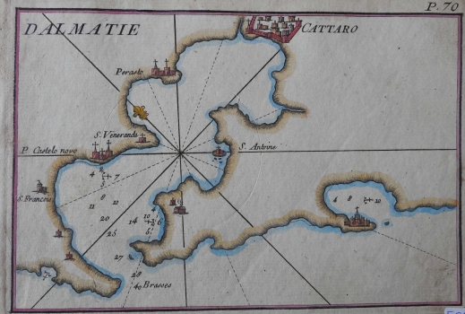
Original title: Cattaro
Publishing year: 1764
Place of publishing and publisher: Marseille
Format: 12 x 19 cm
Technique: Partially coloured copper engraving
This rare maritime chart shows the Bay of Kotor with Kotor (Cattaro) at the top of the bay. Several individual pieces of data on sea depths expressed in fathoms (Brasses) were indicated at the entrance to the bay. They were certainly important to the French royal hydrographer Joseph Roux, the author of the chart. Anchors are drawn at two locations in the Bay of Kotor and one in the Bay of Budva. Northeast is on the top of the chart, which can be seen from the lily in the compass rose. It is interesting that this plan does not have its own graphical scale. Apart from Kotor, where houses are represented by ground plans inside city walls, settlements are still marked mostly by church graphics as navigational markers visible from the sea, especially in Perast (Perasto), Risan and Herceg Novi (P. Castelo novo) and in Tivat (S. Antoine). This plan was first published as a part of the collection Recueil des Principaux Plans, des Ports, et Rades de la Mer Mediterranée in 1764 and again in Livorno in 1858.
ROUX, JOSEPH
ROUX, JOSEPH (1725-1793), a French cartographer and hydrographer, most productive in the second half of the 18th century. He also made navigational instruments. He worked in Marseille, where he printed, published and sold his own maps and nautical instruments. In the mid 18th century, he received the honorary title of the royal hydrographer (Hidrographe du Roy), and in 1764 he published a series of 12 maps of the Mediterranean (Carte de la Mediterraneé), and after that a small atlas, comprising about 100 plans of the ports in the Mediterranean. Subsequent variants of this atlas would appear throughout the entire 19th century, as a sort of “people’s atlas”. The maps depict territory from France to Italy, mostly with the following accompanying dedication: Recueil Des Principaux Plans, des Port, et Rades de la Mer Mediterranée, Estraits de ma Carte en Douze Feuilles DEDIEE A MONS.gr.LE DUC DE CHOISEUL Ministre de la guerre et de la Marine gravee avec Privilege du Roy. Only very few have survived and those that have are considered to be a true rarity. The dedication refers to Étienne-François, Duke of Choiseul, who was the French Minister of War and the Navy at the time. The first and only edition of the collection with all 170 maps was published in 1764, and today it is a rarity, with its title page in the style of Rococo and depictions of ports throughout the Mediterranean. Particularly represented were the Eastern Mediterranean ports, which had been rarely analysed on nautical maps and portulan charts up to the mid 18th century. The French explorations of the Levant between the 1730s and the 1760s were mostly undertaken by Chambert, and his son Joseph Roux introduced some novelties in 1764. The same principles of mapping were used by Nelson 40 years later because of the intended purpose of the maps, which were to be used by the very seafarers. Despite the popularity of the edition, the French prohibited its further duplication in the 1770s. According to some sources, there were three different versions of this atlas. The first abridged edition comprised 66 maps, the majority depicting the sites of the western Mediterranean. It was followed by the official edition comprising 121 maps of the entire Mediterranean, with the Eastern Mediterranean being represented only by maps of the most significant ports and hubs. Finally, the third edition was published, which comprised all 170 maps and was intended for sailing the Levant.