SCHEDA, JOSEPH: THE AUSTRIAN EMPIRE
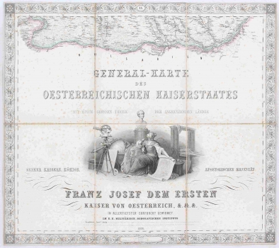
Scheda participated in the production of this Austro-Hungarian General Map in 20 sections with the help of associates from the Military Geographic Institute (k.k. Militärisch-Geograf. Institut) in Vienna, where he was employed. An extra sheet serves as a review chart. The map was made at the scale of 1: 576,000 based on the Francis I (Franz I) topographic survey data. Within this survey, a systematic cadastral survey of the entire Habsburg Monarchy was conducted, and Croatian countries received the first systematic cadastre. The Patent on Stable Cadastre, introduced by Francis I in 1817, was the legal basis for the compilation of the cadastre, intended to reform the tax system and make it fairer. The map is of a high technical quality, but it has is cluttered, which is why its legibility is reduced. Among the numbered lists of this map, one sheet represents the title cartouche (sheet XX), while sheet XIX serves for general explanation.
The title sheet is decorated with artwork of a woman in an art-science salon. She is surrounded by documents, maps, globes and measuring instruments. The sheet number (XX) is in the top decorative edge. Dedication to Emperor and the King Fracis Joseph I (Franz Joseph I), Scheda's authorization, and the information about the Institute which published this map is below the graphics. The graphic scale is at the very bottom. The cartographic representation of the lower flow of the Danube River, in the central part of Romania and Bulgaria (Bulgarien), although Bulgaria does not have any map data, occupies the upper part of this very decorative sheet. Omitting cartographic content of neighbouring countries which were not under Austrian administration is in line with a part of the title declaring the content of the map as: General-Karte des Oesterreichischen Kaiserstaates mit Einem Grossen Theile der Angrenzenden Länder.
The overview map on a separate non-numerated sheet shows a distribution of all numbered sheets which represent the territory of "Austrian Countries", from I in the northwest (Frankfurt), through Prague and Krakow further east, to the sheet Lvov no. V (Lemberg) in western Galicia, second row from Innsbruck (list VI), München (VII), Vienna (VIII) and Debrecen (IX) to Cluj (Klausenburg) in the east. The third row begins with the map of Verona (XI) and Trieste (XII) in the west, followed by a map of Zagreb (Agram) no. XIII, Srijemski Karlovci, and finally no. XV, a map of Bucharest (Bucarest) in the east. The lower row from the west represents sheets no. XVI Florenz, XVII Ancona, XVIII Spalato and XIX Kruševac. The aforementioned title map with the lower course of the Danube in Bulgaria is on no. XX. The map legend is in the lower part of sheet no. XIX.
SCHEDA, JOSEPH
