SCHLIEBEN, WILHELM ERNST AUGUST VON: LJUBLJANA, KLAGENFURT, VILLACH
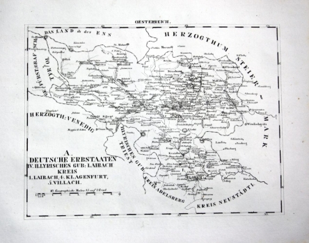
The map depicts German countries in the administrative unit of the Kingdom of Illiria – gubernium Ljubljana. It is a part of the Duchy of Carniola and a part of the Habsburg Inner Austria. The Duchy of Carniola comprised a wider area than the medieval Carniola. Further administrative division of Ljubljana gubernium includes districts no. 1 Ljubljana (Laibach), no. 4 Klagenfurt and no. 5 Villach. Boundaries of Carniola are marked to the Duchy of Styria in the north, the Shire of Tirol in the northwest, and the Primorje gubernium with the centre of Trieste in the west. Lines of internal boundaries between regions are less legible, which are precisely classified in the title text in the lower left corner. The Primorje gubernium remained outside the cartographer's focus. Minimal data are represented in this area. It is interesting that the Ljubljana district in the south is bordered by Postojna (Adelsberg), Notranjska in the west and the Novo mesto (Neustaedtl), i.e. Dolenjska in the east. These two counties of Carniola, together with Gorenjska, are Slovenian historic land. The graphic scale expressed in geographic miles is below the title. The map is specific for its routes and road infrastructure. They connect the prominent centres Ljubljana - Kranj (Krainburg) - Klagenfurt in the northeast direction, with a branch to the west towards Tarviso. From Klagenfurt, the road leads to Spital, then branches to the east towards Gmünd (Gemünd) and towards Greifenburg to the west. Klagenfurt as the regional centre has the best road network and the network of toponyms is the densest around it. Relief is completely omitted. Geographic coordinates are marked and the label of the sheet OESTERREICH is above the upper edge of the map. The map was also produced by O. Hermann and was published by Georg Joachim Goschen.
SCHLIEBEN, WILHELM ERNST AUGUST VON
