SCHLIEBEN, WILHELM ERNST AUGUST VON: MARIBOR, STYRIA
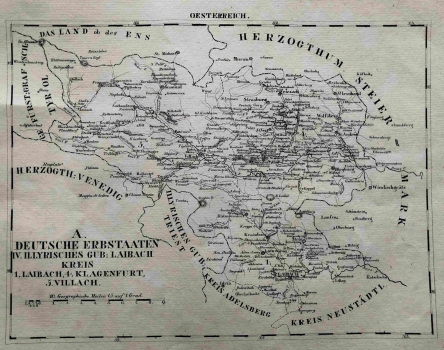
The map depicts German countries in the administrative unit of the Duchy of Carniola, part of the Habsburg Inner Austria. After the disintegration of Napoleon's Illyrian Provinces of the Kingdom of Illyria, it united a part of the Slovene and Western Croatian countries to a common state which existed from 1816 to 1849. Styria on this map is administratively divided into Graz (Graetz), Maribor (Marburg), Celje (Cilley) and Bruck on Mura. the map is dominated by many toponyms of the Styrian space and the dashed boundary of the administrative divisions in the districts. This content is included in the title text in the lower-right corner. Outer borders were also marked to the Duchy of Carniola in the southwest (Illyrian gubernium Laibach), the Judenburg district in the northwest, the Upper Austrian and Lower Austrian "countries above and below Ens" in the north, the Kingdom of Hungary to the east and the Civil Croatia (Provincial Kroatien) in the southeast. The graphic scale expressed in geographic miles is in the lower left corner. The map is specific for its routes and road infrastructure, which connects highlighted centres and follows natural features of the space. Relief is completely omitted. The hydrography of this perialpine and rich water area is relatively accurate, and the dense road network as well as the network of toponyms in the neighbourhood labels all four regional centres. Geographic coordinates are marked and the label of the sheet OESTERREICH is above the upper edge of the map.
SCHLIEBEN, WILHELM ERNST AUGUST VON
