SCHLIEBEN, WILHELM ERNST AUGUST VON: MAP OF BOSNIA / RUMILI
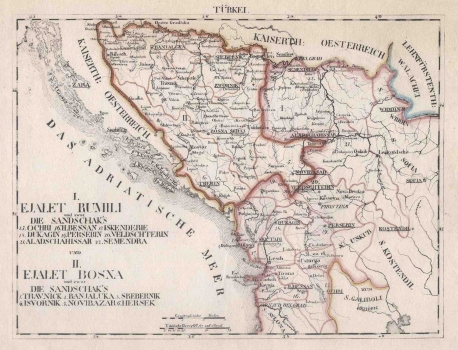
Since the 14th century, Rumeli was the Ottoman acquis on the Balkan peninsula, and despite the establishment of Buda Eyalet, and later the Bosnia Eyalet in 1580, the 19th century name was synonymous with Ottoman territories in Europe. In this case, Eyalet Rumili covers territories to Serbia and Albania, divided into eight sanjaks (another name for the territorial unit eyalet before 1860), while Eyalet Bosnia, separated by a prominent red line, includes Travnik (Bosna Serai), Banja Luka, Srebrenica, Zvornik, Novi Pazar and Hersek sanjak. The last one is mentioned in the legend, while the Montenegrin Trebin is marked with the same number (6.). This partly corresponds to the reorganization of the vilayet with the governor led by 1865, with the exception that the Travnik, Bihać and Hercegovina sanjak were not especially separated. The content was not drawn in the area north of Sava and in Dalmatia, but it was recorded that these were imperial territories of Austria. The title legend with a detailed list of sanjaks is in the lower left corner. Apart from hydrographic and major roads, geographic content is completely omitted, and the borders constitute the dominant map content. The graphic scale expressed in geographic and Turkish miles is at the bottom edge of the map. Geographic coordinates are marked and the label of the sheet Türkei is above the upper edge of the map.
SCHLIEBEN, WILHELM ERNST AUGUST VON
