SCHLIEBEN, WILHELM ERNST AUGUST VON: MAP OF BOSNIA AND SERBIA
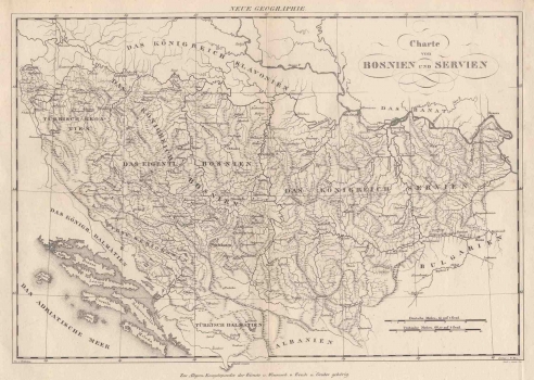
The Kingdom of Bosnia (Das Köenigreich Bosnien) and the Kingdom of Serbia (Das Köenigreich Servien) are represented on this map , as well as political boundaries created after the Turkish conquest in these territories. In addition to the old medieval royal horonym, the name of "real Bosnia" (Das Eigentlich Bosnien) extends to the area of central Bosnia, suggesting that Bosnia is different than the medieval kingdom. On the other hand, the Austrian cartographer continues to record traditional, i.e. medieval toponymy, because Slavonia and Dalmatia are called kingdoms, ignoring the actual state, that is, the Ottomans and Venice as new actors in the space. In addition, the Province of Herzegovina, included in "real Bosnia", was not associated with Ottoman Dalmatia (Türkisch Dalmatien), which other cartographers usually did. The space between Una and Vrbas is named after the old name Türkisch Kroatien. The simple title cartouche is in the upper right corner. The relief is shown with concatenate molehills, rather schematically, so that it does not give the impression of plasticity and dynamics. Graphic scale expressed in German and Turkish miles is located in the bottom right corner. Geographic coordinates are marked, and the label Neue Geographie is above the upper edge of the map. Below the bottom edge of the map, the author recorded that the map is a part of the Allgemeine Encyclopädie der Wissenschaften und Künste, a famous German encyclopaedia published by Johann Samuel Ersch and Johann Gottfried Gruber from 1830 onwards. Nevertheless, the quality of data of the Bosnian interior in the first half of the 19th century significantly deviates from materials collected of the northern Ottoman-Austrian frontier of previous decades by Austrian topographers. Geographic insights of the interior were improved only at the end of the 19th century, with systematic measurements throughout Bosnia and Herzegovina.
SCHLIEBEN, WILHELM ERNST AUGUST VON
