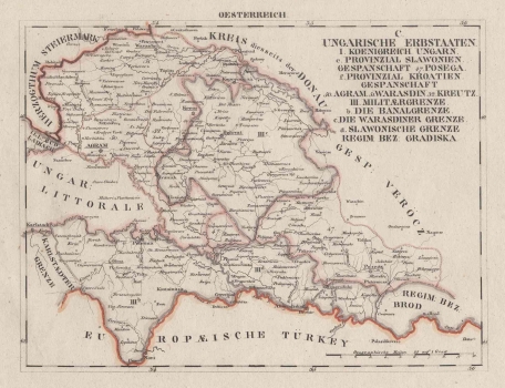
SCHLIEBEN, WILHELM ERNST AUGUST VON: MAP OF SLAVONIA AND PART OF CROATIA
The map depicts civilian and military Slavonia and Croatia prior to the demobilization of the Military Frontier and its return under the jurisdiction of the Croatian Parliament in 1881. The cartographer used a gray boundary to separate the civilian Slavonia from the Slavonian military frontier, which was divided into the Gradiška and the Brod Regiments after their reorganization in 1746. The Petrovaradin Regiment is not represented . There is clearly visible administrative or political division into the Austrian influence zone in the military part, divided into regiments, and the Hungarian area of influence in the civilian part (Provinzial Slawonien). In addition to the part of the Gradiška border Regiment (R. Gradiska), the Brod Regiment (Regimentbezirk Brod) was also separated. Civil Slavonia was divided into Požega, Virovitica and Srijem County from 1745. The last two counties are not shown on the map. The counties were directly represented in the Hungarian Parliament as Hungarian lands of the Kingdom of Hungary, as evidenced by the legend of the administrative divisions in the title cartouche in the upper right corner of the map. Civil Croatia (Provinzial Kroatien) was divided into Varaždin (Warasdin), Zagreb (Agram) and Križevci (Kreutz) counties. The Austrian Military Frontier is separated from Civilian Croatia by a gray boundary, especially in the Varaždin Generalate (Warasdiner Grenze) and Banovina Frontier (Banalgrenze). The boundary is also drawn to the Karlovac Generalate (Karlstaedter Grenze) although this territory is omitted. The Duchy of Styria is separated in the north by a red boundary, and the Ottoman Empire territories are separated by the Sava River (Europeische Türkei). Major road communications are marked on the map as economically significant content and larger cities are connected with a road network. Relief is completely omitted. The graphic scale is located at the bottom right corner. Geographic coordinates are marked, and the label OESTERREICH is above the upper edge of the map. O. Hermann also worked on the map, and Georg Joachim Goschen published it in Leipzig.
SCHLIEBEN, WILHELM ERNST AUGUST VON
