RADEFELD, CARL CHRISTIAN FRANZ: MAP OF THE ILLYRIAN KINGDOM
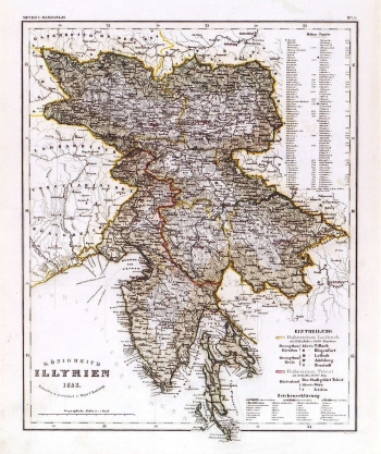
This map was published in the "Hand Atlas" by Joseph Meyer". It shows the area that at the beginning of the 19th century was making part of the Napoleon's Illyrian Provinces. It shows the province of Ljubljana comprising the duchy of Carniola with districts of Villach and Klagenfurt and Carniola with districts of Postojna and Novo Mesto. The province of Trieste i.e. the region of Primorje (Küstenland) comprised the city-district of Trieste, Gorica and Istria. In the upper right corner there is a list with elevation points. In this map, the routes of the first railway tracks constructed in Slovenian territory are indicated. The construction of railways started in these parts in the 40s of the 19th century (bold black line). A mileage scale is in geographical miles (geographischen Meilen). The title of the map is in its lower left corner.
RADEFELD, CARL CHRISTIAN FRANZ
