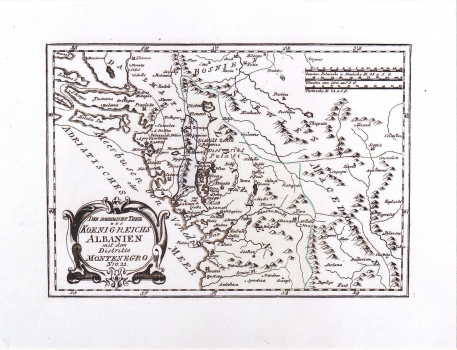
REILLY, FRANZ JOHANN JOSEPH VON: MAP OF THE NORTHERN ALBANIA AND MONTENEGRO
The map shows the northern part of Albania. Although at that time it was making part of the Ottoman Empire together with Serbia and Macedonia, their mutual boundaries are also indicated. Delineated a part is Montenegro at that time within its smallest space-area (so-called the old Montenegro). The delineation of its borders is made with a lot of mistakes. Namely, at that time Montenegro wasn't a maritime country. The whole territory of Montenegro is elongated in north-southerly direction. The border of the Republic of Dubrovnik is indicated, but without indication of the Turkish cordon at Sutorina that already existed. Numerous mistakes present in this map witness that the European cartographers still had only vague notions of this territory. The title of the map is shown in a cartouche in the lower left corner of the map. A mileage scale is in Italian, Turkish and German miles. This map was published in Reilly's atlas "Schauplatz der Welt Atlas" 1789-1791.
REILLY, FRANZ JOHANN JOSEPH VON
