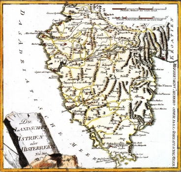
REILLY, FRANZ JOHANN JOSEPH VON: MAP OF ISTRIA
Inventory number 166
Author: REILLY, FRANZ JOHANN JOSEPH VON
Original title: Die Landschaft Istrien oder Histerreich: Nro 520
Publishing year: 1789
Place of publishing and publisher: Wien
Format: 23,3 x 25,5 cm
Technique: Coloured copper engraving
The map shows Istria with the outline of its administrative units as they were at the end of the 18th century. Interestingly, the border between the County of Pazin under Hapsburg rule, at the time, and the rest of Istria, then under Venetian rule, is not distinctively marked. The main district centres are identified in red. The title is in the lower left corner of the map contained in a stone-monument shaped decoration. A mileage scale is in German and standard Italian miles. This map was published in Reilly's atlas "Schauplatz der Welt Atlas", 1789-1791.
REILLY, FRANZ JOHANN JOSEPH VON
FRANZ JOHANN JESEPH VON REILLY (1766-182), a Viennese cartographer, publisher and merchant. His most famous work is "Schauplatz der Welt Atlas" 1789-1791, that includes a number of maps of the Croatian lands. It was printed in Vienna in the printing house of Ignaz Albrecht. Other Railly's works of importance are "Deutscher Atlas" of 1796 and "Atlas Univ." of 1799.
