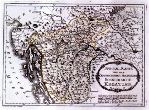
REILLY, FRANZ JOHANN JOSEPH VON: MAP OF THE KINGDOM OF CROATIA
The map shows the Croatian Kingdom within its medieval boundaries. Separately indicated is the territory of the so called Turkish Croatia lying between Una, Vrbas and Pliva that before the invasion of the Turks were part of Croatia and after Turkish invasion were included to form part of Bosnia under the rule of the Ottoman Empire. The rest of the Croatian territory Reilly identified as Austrian Croatia as at that time it was under the rule of the Austrian Monarchy. The delineation of boundary as fixed by the Peace Treaty of Požarevac of 1718 is indicated (broken line) as well as the boundaries between the military and civilian Croatia and Slavonia (doted line). Apart from boundaries the map shows the network of postal routes and stations. Reilly identified the Carolina and Josephine roads, through which flowed considerable amounts of commercial traffic between Karlovac and Rijeka and Senj respectively main exporting Adriatic ports at the time. The title of the map is in the lower right corner displayed within a floral wreath. Below the map’s margin, in the lower left corner, the signature of the craftsman is placed “Gestochen von Ignatz Albrecrt”. A mileage scale is expressed in Italian, Turkish and German miles. This map comes from Reilly’s atlas “Schauplatz der Welt Atlas” 1789-1791.
REILLY, FRANZ JOHANN JOSEPH VON
