REILLY, FRANZ JOHANN JOSEPH VON: MAP OF NORTHERN ISTRIA
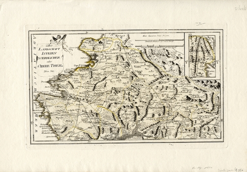
This is one of the 3-section map of Istria published in Reilly’s atlas entitled “Schauplatz der Welt Atlas” issued sometime between 1789-1791. This Reilly’s map shows the northern part of Istria reaching as far north as Muggia (Italy) and as far south as Završje (Piemonte). The author was focused on the representation of roads (post roads) and administrative organization of Istria (pink lines). Particularly interesting are the representation of the river Mirna with its tributaries and a vast marshy zone and that of the river Dragonja. The top right inset map shows the South Eastern part of Istria located between Veprinac and Kastav. The title of the map in the upper left corner of the map in a cartouche having the form of a curtain held by an angel. The map’s mileage scale is in both German and Italian miles.
REILLY, FRANZ JOHANN JOSEPH VON
