WESTERN PART OF ILLYRIA
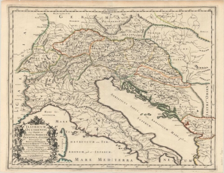
This very late map of the eastern and western coasts of the Adriatic “renews” or glorifies the tradition of ancient maps, which were re-valorised in the centuries that preceded this map. During this period numerous cartographers made extensive use of the Ptolemy legacy and reproduced, refined and published their own plates as adaptations of the original Ptolemy tabulas or supplemented them with new maps (tabulae modernae or novae). The esteemed French cartographer Sanson and the publisher Mariette refer to the ancient administrative-territorial units in the eastern Adriatic mainland, all the way to the Drava and the Danube in the north and east, in a very turbulent (both politically and militarily) 18th-century time, especially in southeastern Europe. Their work represents the pinnacle of French cartography of the Early Modern Period. Even the title cartouche lists the provinces shown (Rhaetia, Noricum, Pannonia (Prima et Secunda) et Illyris), and even the population living in Illyric (Populi Iapodes, Liburni et Dalmatae). It is interesting that during the Ottoman expansion in this region, French cartographers even considered the conquered regions as an integral part of the Western European (ancient) civilization. The template for this map were versions made according to Ptolemy's original Fifth Maps of Europe, some of which are included in the Felbar Collection (e.g. Mercator map no. 268, Magini no. 547, Rosaccio-Magini Map no. 569, Ruscelli no. 70, Münster no. 120, Stirk no. 33 and Waldseemüller maps no. 97, 105 and 269). This item also shares design features with Munster’s map due to the cartouche with narrative descriptions placed in the lower left corner. The content was inscribed into the copper plate by Louis Cordier for Sanson. But the interesting thing about this item is that the original copper engraving with the ancient division of the territory was subsequently manually coloured, precisely along the lines of the subsequent border divisions between the great powers that claimed these lands during the 18th century. The border between the Venetian and Austrian land is therefore clearly visible in the Istrian area, which corresponds to the military-political divisions of the Early Modern Period, regardless of the fact that the toponyms or horonyms as a cartographic background from the original copper plate date to the Roman period. The eastern Croatian territory also highlights in colour the Austrian land acquired under the Požarevac Treaty in 1817, with the border towards the Ottomans moved south of the Sava River.
SANSON, NICOLAS
