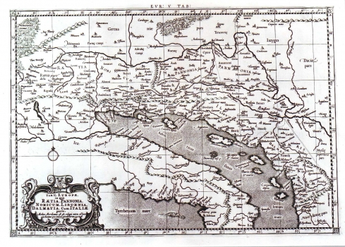
STIRK, LEONARD: THE 5TH MAP OF EUROPE
Inventory number 33
Author: STIRK, LEONARD
Original title: Tabula V Europae V in qua Raetia, Pannonia, Noricum, Liburnia, Dalmatia cum Italia parte
Publishing year: 1695
Place of publishing and publisher: Amsterdam
Format: 33 x 46 cm
Technique: Copper engraving
This was Leonard Stirk's redesign of the" 5th map of Europe" by Ptolemy's. It was issued in the "Univ. Tabula juxta Ptolemy" published by Francois Halma in Amsterdam in 1695. The map shows the Roman provinces of Raethia, Pannonia, Noricum, Liburnia, Dalmatia and parts of Italy. It features only antique place names. The title is shown in a cartouche drawn in a late Renaissance style with masquerons and fruit festoons.
STIRK, LEONARD
STIRK, LEONARD was an associate of Gerard Mercator and the publisher Francois Halma on several revised cartographic publications of maps that were originally from Ptolemy's Geographia, published in the Netherlands in the late 17th century. An example of this is the work Universalis Tabula juxta Ptolemaeum, for which Stirk made the maps, and which was published in 1695 in Amsterdam by Fancois Halma.
