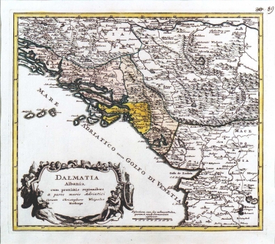
WEIGEL, JOHANN CHRISTOPH: MAP OF DALMATIA AND ALBANIA
Inventory number 121
Author: WEIGEL, JOHANN CHRISTOPH
Original title: Dalmatia, Albania cum proximis regionibus & parte maris Adriatici / curante Christophoro Weigelio
Publishing year: 1718
Place of publishing and publisher: Nürnberg
Format: 32 x 37 cm
Technique: Coloured copper engraving
This map shows the Republic of Dubrovnik and the Venetian possessions in Dalmatia and Albania. The border that outlines Dalmatia in respect to the Turkish possessions is not accurate, as includes the whole Herzegovina, a part of Bosnia and much of Montenegro. The borders of the Republic of Dubrovnik are also shifted to the northeast. The territory of Albania is also groundlessly enlarged to the northeast, including a part of Kosovo. The title of the maps is in the lower left corner in a baroque oval cartouche. A mileage key is expressed in Italian miles (Milliaria Italica).
WEIGEL, JOHANN CHRISTOPH
JOHN CHRISTOPH WEIGEL (1654-1725), a German graphic artist and editor active in Nürnberg. His most famous works are "Atlas Scolasticus", 1712, "Orbis Antiquis", 1720, "Reise Atlas", 1724 and "Bequemer Schul und Reisen Atlas", including 140 maps that he produced together with Johann David Köhler.
