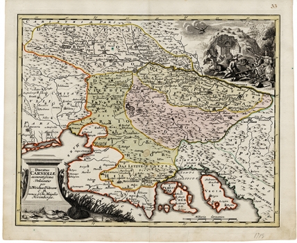
WEIGEL, JOHANN CHRISTOPH: MAP OF THE DUCHY OF CARNIOLA
This map was published in the work “Schul und Reisen Atlas” by Johann Davida Koehler in 1719. It shows Carniola (its upper, central and lower parts), as well as all of Istria. This Weigel’s map was modelled upon the map of the Slovenian political historian Johann Weichard Valvasor (1641-1693) entitled “Carnilola, Karstia, Histria et Windorum Marchia” and published in 1681 by Ludwig Schoenleben, and then by Valvasor in his noted work “Slava vojvodine Kranjske” (The Glory of the Duchy of Carniola) from 1689. The author was obviously much better acquainted with the region of Carniola than with the regions of Istria and Kvarner. The outline of Istria shows serious deformations. The Austrian part of Istria, i.e. the Principality of Pazin, is named as “Das letzte funftheil Histrae” (the last fifth of Istria). The island of Cres is shown as being made up of three islands – its central part is identified as Cherso, the northern part with the port Porozinom as Perosina and the northeast part of the island around the locality Beli as Cao. The representation of the island of Krk also contains many deformities. In the upper right corner of the map the view of Podjama is featured together with the image of an allegorical lion. The title of the map is in the lower left corner contained in an attractive cartouche embellished by the floral decorations and drawings featuring fishing-net and fish.
WEIGEL, JOHANN CHRISTOPH
