WALDSEEMÜLLER, MARTIN: THE 5TH MAP OF EUROPE
Inventory number 97
Author: WALDSEEMÜLLER, MARTIN
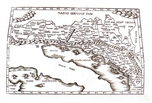
Original title: Tabula V Europae
Publishing year: 1541
Place of publishing and publisher: Vienne
Format: 30 x 46 cm
Technique: Colored woodcut
Ptolemy's map of Europe edited by Waldseemüller in Vienne - Dauphine region, was published at Melchior and Gaspar Treschel. From the previous one, (ref. catalogue No. 120), differs only by not being coloured. It shows the Roman provinces Raethia, Vindelica, Noricus, Lower and Upper Pannonia, Illyricum and Dalmatia. It is almost identical to Münster's issue of the same map (ref. catalogue No. 120). These two maps differ between each other only by their coloring.
WALDSEEMÜLLER, MARTIN
MARTIN WALDSEEMÜLLER (1470-1521) - a cartographer from Alsace. He had his schooling in Freiburg and exercised cartographic activities in St. Dieu within a frame of French cartographic traditions. On his world map of 1507 he was the first in using the word America. He issued several editions of Ptolemy's Geographia, which he published in Strassburg (1513, 1520). Some of his Ptolemy's editions appeared after his death (1525, 1535 in Lyion and in 1541 in Vienne).
