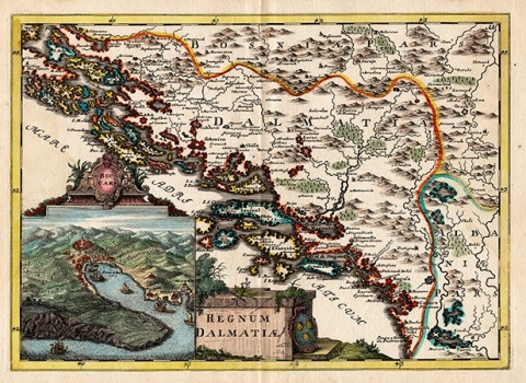
VAN DER BRUGGEN, JOHANN: MAP OF DALMATIA
Inventory number 441
Author: VAN DER BRUGGEN, JOHANN
Original title: Regnum Dalmatiae
Publishing year: 1740
Place of publishing and publisher: Augsburg
Format: 23,4 x 32,5 cm
Technique: Coloured copper engraving
The map shows a greatly enlarged area of Dalmatia that covers the coast from Senj to Pastrović. It almost reaches Sarajevo in the north and Podgorica in the east. Besides the coat of arms and cartouche, there is a very beautiful view of the Bakar Gulf from the semi-perspective in the left lower corner, with the city of Bakar and mountains in the background. The expert use of colour contributes to the impression.
VAN DER BRUGGEN, JOHANN
VAN DER BRUGGEN, JOHANN (1695-1740), an engraver in Prague and Vienna, who in 1737 published maps of Austria in 11 sheets. For Croatian cartography, the following sheets are of significance: Regnum Croatiae, Regnum Slavoniae, Regnum Dalmatiae, Regnum Bosniae.
