VAN DER BRUGGEN, JOHANN: MAP OF CARINTHIA
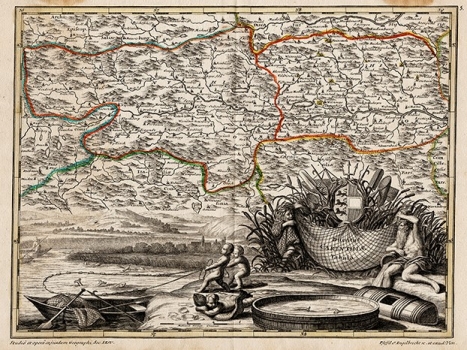
Map of the Duchy of Carinthia was published in „Parvus Atlas...“, which was printed in Vienna and Augsburg. It is evident from the signature on the map that it is a Viennese edition for the Society of Jesus. Although van der Bruggen’s authorship is almost indisputable, according to all the stylistic characteristics of the map and the signatures of authors and copper engravers, J. A. Pfeffel and C. Engelbrecht, it is very difficult to ascertain what relationship they were in. The fact is, however, that maps signed by van der Bruggen or have no signature have different types of letters, which are less slanted and therefore much more legible. The map depicts the Duchy of Carinthia, divided into Upper (Upper) and Lower (Inferior), which is mostly in Austria and, to a lesser extent, in Slovenia. When the map was produced, it belonged to the Habsburgs, but it had a semi-autonomous status. The map contains many toponyms, and great attention is dedicated to relief and river network. The map’s distinguishing characteristic is that almost half of it is occupied by a lavish baroque cartouche and the view, it seems, the Wörth Lake and the three small fishing cherubs.
VAN DER BRUGGEN, JOHANN
